South DakotaDepartment of Transportation
Transportation
Aviation
About Office of Aeronautics Services
Office of Aeronautics Services
Airports Conference
Aerospace Education
Airport Information
Links
Aviation Systems Plan
Bridges
Office of Bridge Design
Design & Plans
Historical Bridges
Inventory & Inspection
Posted Structures
Reference Information
SD Bridge Photos
Doing Business
Certification & Accreditation
About Certification & Accreditation
SDDOT Accreditation Certification List
Approved Products
Manuals & Documents
Welding Certifications
Training
Contractors
Bid Letting Information
Concrete Pipe Release
Contractors/Suppliers
Prequalified Contractors
CMS Web Reports
Disadvantaged Business Enterprise (DBE)
Fuel Price Index
Labor Compliance
Materials
Preconstruction Meetings
Price Adjustment Guidelines
Standard Specifications
Subcontract Requirements
Forms & Documents
Webinars
Alternative Contracting
Engineering/Design Services
Consultant Services
Downloadable Files
Manuals
News & Updates
Right of Way / Relocation Assistance
Standard Bid Items
Standard Plates
Surveyors
Utility Coordination
Environmental
About Environmental
Agreements
Endangered Species
Environmental Assessments
Forms
Public Involvement
Stormwater
Wetland Mitigation
Local Governments
About Local Governments
Bridge Improvement Grants
City/County Fund Balances
Emergency Relief (ER)
Federal Bridge Program
Forms & Documents
Secure Accounts Billing
Transportation Economic Development Grants
Urban Systems
Rural Access Infrastructure Fund Program
Traffic Incident Management
Training
Projects & Studies
Planning
Carbon Reduction Strategy
Freight Plan
Long Range Plan
Metropolitan Planning Organization
Non-state Public Road Inventory
Pavement Condition Monitoring
Pavement Management
South Dakota EV Fast Charging Plan
Statewide Transportation Improvement Program – STIP
Transportation Asset Management Plan (TAMP)
Construction Projects
Inside SDDOT
Forms & Publications
Brochures
Forms
Manuals
Maps
Newsletters
Reports
SDDOT Engagement Opportunities
Join One of Our Contact Lists
Press Releases
Media Kits
News Stories
Branding and Identity Guidelines
Learn More about the SDDOT Logo
SDDOT Blog
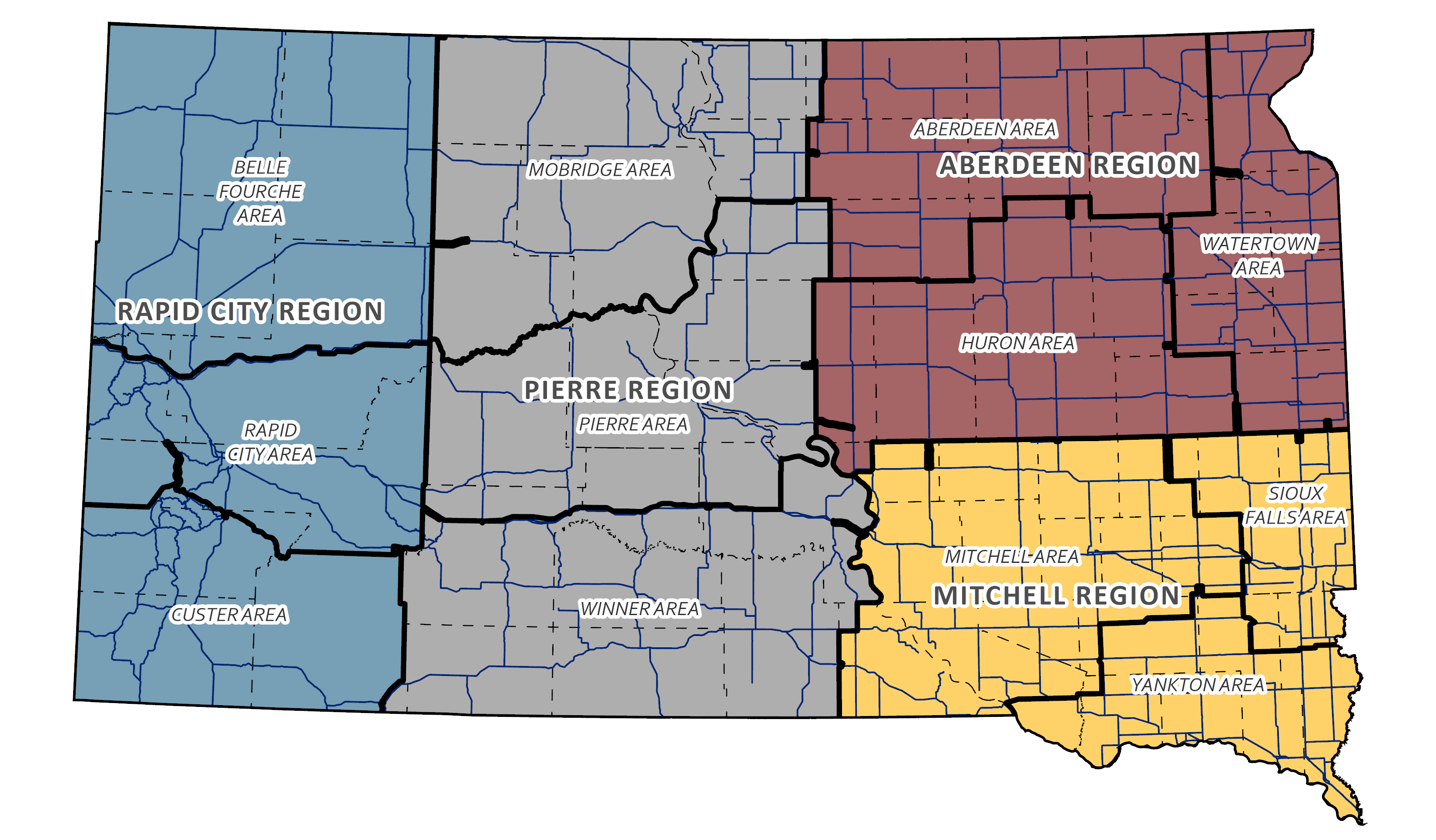
Maps
Maps
CADD Mapping
CADD Mapping creates, designs, and maintains state, counties, and South Dakota cities maps. These maps are used extensively by planning agencies, in road design, and the public for a variety of purposes. CADD Mapping also produces the Official State Highway Map.
View ALL CADD Maps
GIS (Geographic Information Systems) Maps
Examples of GIS products include iPad applications for collecting field data, interactive mapping applications, story map applications, and specialized maps.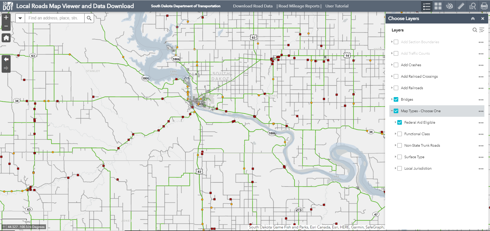
View ALL GIS Maps