South DakotaDepartment of Transportation
Transportation
Aviation
About Office of Aeronautics Services
Office of Aeronautics Services
Airports Conference
Aerospace Education
Airport Information
Links
Aviation Systems Plan
Bridges
Office of Bridge Design
Design & Plans
Historical Bridges
Inventory & Inspection
Posted Structures
Reference Information
SD Bridge Photos
Doing Business
Certification & Accreditation
About Certification & Accreditation
SDDOT Accreditation Certification List
Approved Products
Manuals & Documents
Welding Certifications
Training
Contractors
Bid Letting Information
Concrete Pipe Release
Contractors/Suppliers
Prequalified Contractors
CMS Web Reports
Disadvantaged Business Enterprise (DBE)
Fuel Price Index
Labor Compliance
Materials
Preconstruction Meetings
Price Adjustment Guidelines
Standard Specifications
Subcontract Requirements
Forms & Documents
Webinars
Alternative Contracting
Engineering/Design Services
Consultant Services
Downloadable Files
Manuals
News & Updates
Right of Way / Relocation Assistance
Standard Bid Items
Standard Plates
Surveyors
Utility Coordination
Environmental
About Environmental
Agreements
Endangered Species
Environmental Assessments
Forms
Stormwater
Wetland Mitigation
Local Governments
About Local Governments
Bridge Improvement Grants
City/County Fund Balances
Emergency Relief (ER)
Federal Bridge Program
Forms & Documents
Secure Accounts Billing
Transportation Economic Development Grants
Urban Systems
Rural Access Infrastructure Fund Program
Traffic Incident Management
Training
Projects & Studies
Planning
Carbon Reduction Strategy
Freight Plan
Long Range Plan
Metropolitan Planning Organization
Non-state Public Road Inventory
Pavement Condition Monitoring
Pavement Management
South Dakota EV Fast Charging Plan
Statewide Transportation Improvement Program – STIP
Transportation Asset Management Plan (TAMP)
Construction Projects
Inside SDDOT
Forms & Publications
Brochures
Forms
Manuals
Maps
Newsletters
Reports
SDDOT Engagement Opportunities
Join One of Our Contact Lists
Press Releases
Media Kits
News Stories
Branding and Identity Guidelines
Learn More about the SDDOT Logo
SDDOT Blog
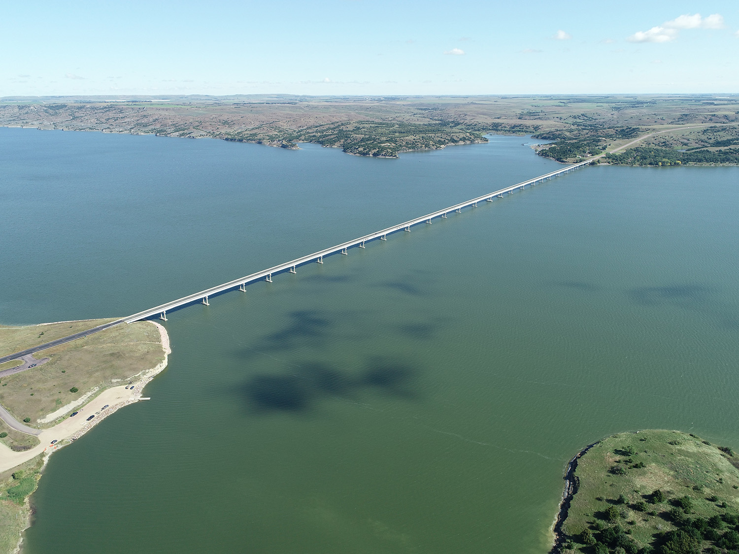
S.D. Highway 44 Platte-Winner Bridge
S.D. Highway 44 Platte-Winner Bridge
Frequently Asked Questions:
Will the existing bridge remain open during construction?Yes! The current bridge will not be demolished until after completion of the new structure and traffic is officially moved to the new bridge alignment. That said, we do anticipate some minor disturbances to mobility through this area during construction. For example, construction activity may cause situations of a lane closure with alternating one-way traffic, or short periods of stopped traffic to accommodate construction equipment movement. These disturbances are expected to be temporary in nature and timed to minimize disruption.
What is the anticipated construction schedule?
How will Snake Creek Recreation Area be impacted?
Improvements are planned to help keep the park fully operational during all phases of construction. This means some work at the park will occur as soon as this fall to prepare for construction. One of the notable improvements will be relocation of the dump station to a new site 1.25 miles east of the current site. Access to the boat launch and parking lot is expected to remain in place during construction, with some potential temporary impacts. We do not expect direct impacts to the campgrounds south of Highway 44. Indirect impacts (such as noise during work hours set by the contractor) are expected - more details about those potential impacts will be better understood when a contractor is chosen.
How wide will the new bridge be?
The new bridge roadway will be eight feet wider than the old bridge. Two twelve-foot lanes will remain in place, but now the shoulders will be six feet wide instead of two feet.
What will happen to the old bridge?
The existing bridge will be demolished and removed from the river after completion of the new bridge and highway. No elements of the old bridge will be visible from above the water.
What is the anticipated construction schedule?
Anticipated Letting Date – 2025
How will Snake Creek Recreation Area be impacted?
Improvements are planned to help keep the park fully operational during all phases of construction. This means some work at the park will occur as soon as this fall to prepare for construction. One of the notable improvements will be relocation of the dump station to a new site 1.25 miles east of the current site. Access to the boat launch and parking lot is expected to remain in place during construction, with some potential temporary impacts. We do not expect direct impacts to the campgrounds south of Highway 44. Indirect impacts (such as noise during work hours set by the contractor) are expected - more details about those potential impacts will be better understood when a contractor is chosen.
How wide will the new bridge be?
The new bridge roadway will be eight feet wider than the old bridge. Two twelve-foot lanes will remain in place, but now the shoulders will be six feet wide instead of two feet.
What will happen to the old bridge?
The existing bridge will be demolished and removed from the river after completion of the new bridge and highway. No elements of the old bridge will be visible from above the water.